F A Q
Hours:
Sunrise to
Sunset
365 Days a Year
Entrance
Fee:
Free
Entrance:
119 Memorial
Blvd.
Dogs:
Leash only, watch for poison ivy.
Return
Trip:
RIPTA Trolley RT 67 and
Trolley
Map Page or walk north on Bellevue Ave. (4.5 miles to Easton's
Beach)
Facilities:
Public restrooms at Narragansett Ave. open during daylight
hours.
Map to Start:
Google
Map to End:
NOT at Ledge Rd.
Google
Official downloadable
map:
Cliff Walk Map
2021
Parking:
Easton's "First"
Beach
175 Memorial
Blvd.
or
Forty Steps
300
Narragansett Ave.
Best
place to view with limited time:
Narragansett
Ave
to Ruggles
Ave.
Handicap
Access:
North end only. Stairs
just south of Marine Ave., each side of Webster St.
Time to Finish:
Currently not
possible
Bike:
Not on walk, but bike stands at Narragansett
Ave.
Baby Carriage:
North end only
Picnic
Area:
None
Emergency:
Cell 911,
note
numbers
stenciled on
walk
Refreshments:
No
Additional Vistor
Information:
(401)
845-5544
Maintenance:
Newport Parks
(401)
845-5802
Liability:
Limited --
Public
Right of Way
over
private
property
Newport's
Cliff Walk
Commission
The Commission minutes on this
link
provide insite into the ongoing operation of maintaining Cliff Walk. (currently
not posted)
(401) 845-5300 |
|
Detour for
repairs starting 3/1/2022
|
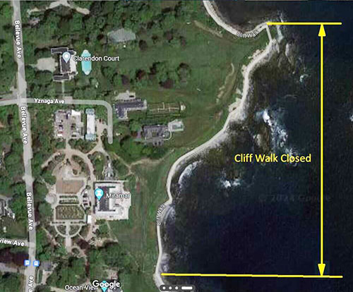
Additional Closure for repairs starting 4/7/2024
(no easy detour, but drop-off/pick-up access at end of Ledge Rd.
)
|
A Short
History of Cliff Walk, click here
|
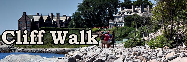
The Cliff Walk along the eastern shore of Newport, RI is world famous as a
public access walk that combines the natural beauty of the Newport shoreline with the architectural history of Newport's gilded age.
Wildflowers, birds, geology ... all add to this delightful walk. shoreline with the architectural history of Newport's gilded age.
Wildflowers, birds, geology ... all add to this delightful walk.
What makes Cliff Walk unique is that it is a
National Recreation Trail in a National Historic District.
In 1975
the walk was designated as a
National Recreation Trail ... the 65th in the nation and first in New England.
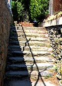
The walk runs 3.5 miles and about two-thirds of the walk is in easy walking
condition.
Parts of the southern half of
the walk are a rough trail over the natural and rugged New England rocky
shoreline. Walkers need to be especially careful and alert in these challenging
areas. RI State Law seems to apply to Limit Liability of property owners. [see
State Law,
Section 32-6]
You pass at your own risk on the walk,
which is a public right-of-way over private property. In spots just a couple of
feet from the path are abrupt drops of over 70 feet. Wild bushes and weeds
often hide this danger.
As you walk
further south you have to scramble from rock to rock and proper shoes are a
must. Even with good shoes, fine sand on some of the rock surfaces can be very
slippery.
One of the main things to watch
for is Poison Ivy which grows well in rainy summer
weather along some areas of the path.
Nevertheless, the walk remains one of the top attractions in Newport and is
taken by people of all ages. Current estimates have a quarter million trips
made each year.
The walk starts at the
western end of Easton's or First Beach at Memorial Blvd. and runs south with
major exits at Narragansett Ave., Webster St., Sheppard Ave., Ruggles Ave.,
Marine Ave., Ledge Rd., and ends at Bellevue Ave. at the east end of Bailey's
Beach locally referred to as
Reject's Beach. |
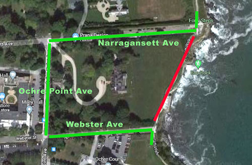
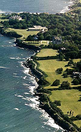
This aerial
overview covers
the northern end of Cliff Walk
with the forty steps in
the middle
and the Breakers in the upper left corner.
[This is the
easy walking part of the Walk.]
 |
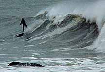
At Marine Ave. there is a
small natural beach [Belmont] that is often used by surfers to launch their
boards when surfing off the "Breakers" on those rare occasions when hurricanes
are passing offshore. |
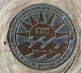
Five State
of RI designated rights-of-way to Cliff Walk are marked with brass plaques at
Webster St., Narragansett Ave., Ledge Rd., Ruggles Ave., and Seaview Ave. |
There are Five unique
segements to Cliff Walk
1. Memorial
Blvd. to Forty Steps
[Map's Green
Line covers paved walk ideal for casual walk or jog.]
2. Forty Steps to Ruggles Ave.
Map's Gold Line covers a close up of Mansions at Salve University
campus; there are several sets of steps.]
3.
Ruggles Ave. to Belmont Beach
[Map's
Magenta line covers a touch of rough terrain and waves breaking near walk when
wind is strong from South.]
4. Belmont Beach
to Ledge Rd.
[Map's Red Line covers
pieces of Rugged Terrain especially at Rough Point, however this is most
rewarding for serious hikers not afraid of heights. ]
5. Ledge Road to Bellevue Ave.
[Map's Blue Line is sometimes missed by Cliff Walkers, but if you
have done segment 4 this is easy and better than walking out Ledge
Rd.] |
Map
controls: 1. lower left corner box toggles between sattelite or map view. 2.
lower right + zooms in, - zooms out.
3. upper right [ ] expands
to full screen. 4. cursor hand allows moving the map where you want. 5. colored
symbols indicate more information and related links. 6. Click on photos to see
larger version. |
It's not just
rocks!
"From Memorial Blvd. to
Ochre Point, south of the Breakers, the rocks are Coal Age black shale,
sandstone, and conglomerate that has metamorphosed to slate, metasandstone, and
metaconglomerate.
"The Coal Age (300
million-year-old) sedimentary rock is important scientifically because it alone
of the major rock masses in the state contains enough fossilized plant remains
to allow geologists to date geologic activity in this region.
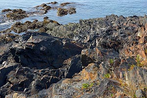 "Ochre Point got
its name from the yellowish (ochre) oxide of iron in the rock, although much of
this has since been removed, covered, or eroded. Continuing south, toward Rough
Point, one can see Precambrian metasedimentary rocks, which mainly consist of
light-colored slate and metavolcanic rock. "Ochre Point got
its name from the yellowish (ochre) oxide of iron in the rock, although much of
this has since been removed, covered, or eroded. Continuing south, toward Rough
Point, one can see Precambrian metasedimentary rocks, which mainly consist of
light-colored slate and metavolcanic rock.
"Past Rough Point occurs the Newport
granite. The granite consists of several types: coarse-grained granite with
large pink feldspar crystals; finer-grained, more evenly textured granite that
cuts through the first type; and numerous quartz veins that can be seen in
almost every rock type in the area."
|
... Preserving Newport's Public Shoreline
Access
This
site is produced and sponsored by WebGhosts.com
in collaboration with
Friends of the Waterfront
[FoW]
Content/Images
© copyright 3.2.2024Webghosts.com, PhotoGhosts.com, Newport, RI -- All
Rights Reserved
CliffWalk.com is always "under construction," If you have
information to add, corrections or suggestions, please contact webmaster at
VJ@WebGhosts.com
|
|
|
|


