| Cliff Walk Interactive Map Instructions Track Your Way Along The Walk [Beta 3.0] |
||
| return to Cliff Walk | ||
| By
using Google Maps you are able to use a smart device such as an Android or
iPhone to track where you are along the Cliff Walk trail. There are five segments to the walk: 1. Memorial Blvd. to Forty Steps [Blue Line] This is the best route for a calm walk, jog or run as this segment is entirely paved with no steps. 2. Forty Steps to Ruggles Ave. [Gold Line] This is the best segment to see mansions up close as it runs along the Breakers and wanders over the open campus of Salve Regina University with its Vinland and Orche Court mansions. 3. Ruggles Ave. to Belmont Beach. [Purple Line] On days with a bit of wave coming in, this allows a cautious person to get up close to the ocean. 4. Belmont Beach to Ledge Rd. [Red Line] This is the most difficult and longest segment of the walk with ungrarded rock climbing sections over unmarked trail. This section is the most dangerous, but still a very popular challenge. The objective is to get to the Bridge at Rough Point. 5. Ledge Rd. to Reject's Beach at Bellevue Ave. [Green Line] While there is some ledge trekking, this segment is relatively good and certainly beats walking back to Bellevue Ave. on Ledge Rd. If you have survived Segment 4 ... this is not a problem. This App does use up battery so keep that in mind. Here is what you need to do: |
||
| 1. You need an active Google Account. Click here to do that. | ||
| 2. Make sure you have the free Google Map
App
|
||
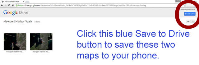
3. Add Maps to the Google Maps App on your
Phone by following this
link, confirm that you have these two maps shown, then
click "Save to Drive." You can add maps to your Google Map App from your
desktop.
|
||
| 4. Open Map on Phone -- hitting the Google
Map icon
|
||
 5. Once in Google Maps
go to "Your Places" 5. Once in Google Maps
go to "Your Places"if you don't get this page ... click and hold left side of screen and slide right ... or touch the gray box in the top left corner. |
||
 6. Select the map in
this next window 6. Select the map in
this next windowby scrolling down to "maps" and click on that map. Unfortunately they like to insert a lot of "other stuff" before you find your maps. |
||
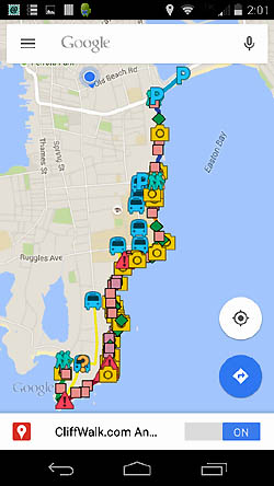 7. The next screen
should be your map 7. The next screen
should be your mapand somewhat look like this.  |
||
 8. Pick a
spot to navigate to ... and press the blue arrow. 8. Pick a
spot to navigate to ... and press the blue arrow. |
||
 9. 9. |
||
10. |
||
| 11. Good Luck and remember this is a Beta version ... we are
always open to input. Thanks ... the WebGhost.com Team |
||
v.7.21.2015 copyright WebGhosts.com and PhotoGhosts.com Newport, RI 02840 and Naples, FL 34102 Base Maps are completely credited to Google. This Newport Harbor Walk website remains under construction. We welcome information or photos anyone would like to share. Web Master |
||